Cycling in the Gargano is the one place in Puglia where riding means climbing: a promontory that rises from the sea to eight hundred metres and drops sheer into the Adriatic. The National Park has mapped twelve marked sections — 4 to 12 kilometres each — linking the Foresta Umbra to the coast between Vieste and Peschici. They are not segregated cycle tracks: they run on existing roads. And the effort is real: the classic loop from Peschici is 61 kilometres with 1,714 metres of climbing.
The only place in Puglia where you need legs
The Gargano is the spur of the Italian boot, and from a bike it is a different region from the rest of Puglia: a limestone massif rising out of the sea and covered at altitude by a beech forest. Anyone arriving with flat Puglia in mind finds real climbs, with gradients from the coast inland that do not forgive. In exchange it has the one thing that is worth gold in summer here: shade.
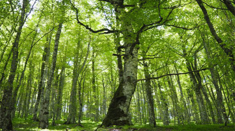
The Foresta Umbra is the heart of the National Park, a high beech wood in the middle of the promontory: it is why the Gargano is the only part of Puglia you can ride in high summer without setting off at five in the morning. The Park’s network runs to about 350 kilometres and carries signage, with a road map published for it.
One clarification that saves disappointment. The Gargano National Park’s cycling network «runs on existing local and provincial roads, predominantly slow-moving»: these are shared-use roads, used by cars, not protected cycle paths. Some are surfaced and quiet, others are unmade. The route was drawn up by the Park together with the Italian cyclists’ federation, so the roads are chosen with a proper cycling eye — but they stay open to traffic, and in high season there is traffic on the Gargano.
The Park’s twelve marked sections
The Park publishes its network as a set of segments to combine, not as closed itineraries. They are short — four to twelve kilometres — precisely so you can build a ride to measure. These are the sections, with the lengths the Park declares.
- Vieste – Valle Tacca del Lupo, about 12 km on tarmac — the climb from the sea
- Valle Tacca del Lupo – La Baracca, about 4.5 km
- La Baracca – Masseria Fusillo, about 7 km
- Valle dei Cacciatori – Masseria Fusillo, about 8 km
- Valle dei Cacciatori – Villaggio Umbra, about 4 km on tarmac
- Villaggio Umbra – Caserma Sfilzi – Il Parchetto, about 7.5 km on tarmac
- Villaggio Umbra – Madonna della Bella – Piscina Scapola – Il Parchetto, about 12 km
- Caserma Sfilzi – Caserma Caritate, about 10 km
- Baracconi – Caritate, about 9 km
- Caritate – Torre di Sfinale, about 12 km — the descent to the coast
- Masseria Fusillo – Torre di Sagro, about 7 km, half unmade and half tarmac
- Torre di Sagro – Ponte, about 12 km
Villaggio Umbra, in the middle of the forest, is the natural hub: four segments start from or pass through it, and the visitor centre is there. Mountain bikes can be hired at the Foresta Umbra and at the Park’s visitor centres, so you need not bring your own.
The ride we suggest if you have two days. Climb from Vieste inland, sleep near the Foresta Umbra, and drop back down to the coast the next day between Peschici and the watchtowers. It is the shape local riders have always described — the climb on day one, the forest in the middle, the sea reappearing on the descent — and it works because you do the climbing once.
The Park has also published a dedicated book, Il Parco Nazionale del Gargano in Mountain Bike, sold at the visitor centres: it is the fullest source if you want individual trails in detail.
How hard it actually is
No authority publishes elevation gain for the Gargano routes, which leaves a rider without the one thing needed to judge whether it is within reach. A GPS track published on Wikiloc for the classic Peschici – Foresta Umbra – Peschici loop gives the measure of the promontory:
Seventeen hundred metres of climbing in sixty-one kilometres is a trained rider’s day out, not an afternoon spin. It says two things at once: that the Gargano climbs from sea level to eight hundred metres without ever giving you a long flat stretch, and that anyone arriving with the Valle d’Itria in mind is looking at a different mountain.
The profile of the loop from Peschici. You start and finish on the sea, and the whole promontory is in between: the climb to the Foresta Umbra and the descent down the far side.
If those are not your legs, there are two ways round it: drive or take a shuttle up to Villaggio Umbra and ride the high sections, which are short and gentle, or hire an e-bike — which makes more sense here than anywhere else in the region.
A GPS track is not official data, and should be read for what it is. It measures what one person rode on one day, not a certified line: another track of the same loop will give a few kilometres and a few tens of metres more or less. It is there to give you the order of magnitude — which is what is missing here — not to plan to the metre.
When to come, and what to allow for
- Bike — the network is designed for mountain bikes; on the surfaced sections a tourer or gravel bike works too.
- Season — this is the only part of Puglia rideable in July and August, thanks to the altitude and the forest. But on the coast, in those months, traffic is heavy.
- Water — springs in the forest are rare: the Sfilzi reserve is known precisely because it holds the only one in the area.
- Climbing — the Park does not publish it for the individual sections. The only reliable order of magnitude is the loop above.
The other areas of the region, and what makes each different, are on the cycling in Puglia page.